When I first heard about the Lost Coast, I was immediately captivated. Take one of the most desolate spots in California, a place that the original Highway 1 builders avoided because it was too rugged, and drop the beautiful ocean, sandy beach, and forested mountains right into the middle of it, and you get an absolutely beautiful and solitary haven for an unforgettable backpacking adventure.
Our trip would take 4 days and 34 miles of hiking across sand, dirt, giant rocks, small streams, and high tides. Since the area was so remote, we only saw a handful of other backpackers during our entire trip. The best part about the Lost Coast was that it would be our own place to enjoy. Read on for a recap of one of the most unique hikes and crazy adventures I’ve gone on!

The beautiful Lost Coast
Day 1: Getting to the Lost Coast & Black Sands Beach to just past Horse Mountain Creek (3 miles)
After a late-night drive and overnight stay at “Chateau” 6, our group woke up bright and early to continue our drive to the Lost Coast. The plan was to grab a quick breakfast and get to the trailhead by 11:30am. We took two cars specifically so we could park one of the cars at the southern endpoint and have a way to get back to the car at the northern starting point, a DIY shuttle system. As I enjoyed some spirited driving along the 101 and cruised along some increasingly narrow and winding mountain roads, I had no idea what was in store ahead. That 11:30am arrival time? It would be 7:30pm by the time we started our hike on the Lost Coast.
Back to our drive. As we wound round and round, we made a few stops to make sure we were going the right direction. By now we were well off the beaten path with no cell signal. We turned into a dirt path on what I thought would be the final few hundred yards to the trailhead parking lot. But instead of a lot, the dirt road continued – getting increasingly more rocky and dusty. We were essentially in an Indiana Jones or Mad Max movie driving the wrong vehicle. The bottom of my German sports sedan scraped against the rocks and the suspension and tires threatened to fail from the off road terrain. After what felt like an eternity of driving, we reached a campsite only to realize we were about an hour-and-a-half south of where we were supposed to be.
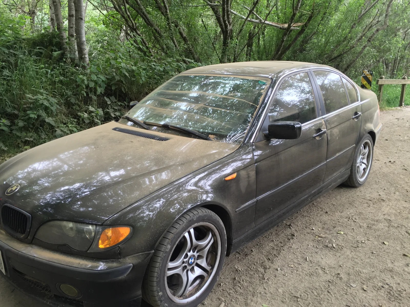
Off-roading in a sports sedan = not a happy driver or car
We took the same route back to the paved road and stopped at a town next to the 101 to regroup. Here the group realized a couple things – we would need to change our original north-south hike route to south-north, because we missed the low tide period for the first day’s impassable section of the trail; and we had until 4pm to rent bear canisters (mandatory on the trail) at the ranger station before they closed for the weekend. Google Maps estimated an hour forty minutes to get there, and we had about an hour fifty before closing time. When the realization hit, we looked at each other and made a dash to our cars.
The race to the ranger station was stressful, to say the least. Once again we found ourselves on poorly-maintained, barely-paved roads, filled with so many potholes I had to constantly swerve around them like in a video game. Some points of the road weren’t even roads at all, just gravel-filled trails that threatened to flatten tires and slowed our pace to a crawl. The clock said 3:45pm and we were still a bit away. We pushed on. If we weren’t going to make the trip, we would’ve at least given it everything we got. It was 3:55pm when we rolled into the station parking lot, after one of the most intense drives in recent memory. We picked up our bear canisters, dropped off a car at the northern trailhead (and now end point) at Mattole Beach, and spent the next hour-and-a-half making the final drive to our starting point, Black Sands Beach near Shelter Cove.

After nearly 10 hours on the road, a fresh start on the Lost Coast
Our feet finally touched the Lost Coast sand at 7:30pm. The fresh ocean breeze seemed to blow our worries and stress away, and we started the hike in high spirits. The beach in front of us was completely empty, with the vast ocean to our left and tall cliffs to our right. The summer sun was still decently high in the sky and the weather was much warmer than expected. Hiking on sand took some getting used to, and we soon figured out that wet sand provided much more solid footing. We were introduced to the solitude of the Lost Coast early on when we walked by a dead humpback whale on the beach. There probably weren’t any rangers or maintenance crews keeping this beach clean and tidy.
We hiked around 3 miles until sunset and set up camp on the sand close to the beach. Everyone lent a hand to prep dinner, and we were starving since we hadn’t had a proper meal since breakfast. Our carne asada burritos with grilled onions, bell peppers, and cheese were delicious. We enjoyed some red wine, set up our tents, and fell asleep to the sound of the ocean waves.

We set up camp the first night right on the beach
Day 2: Horse Mountain Creek to Big Creek (8.5 miles)
All that trouble getting to the trail was worth it. We woke up bright and early the second day to make up for the lost ground. Over the morning we had a blast on our hike, switching between a variety of terrains, from fine sand to rocks to dirt, and crossing a couple of small fresh water streams that flowed from the mountains to the sand directly into the ocean. We passed by an old buried car, several large rusted parts from shipwrecks, and plenty of aquatic wildlife in the tide pools and near the shore.

The Lost Coast – windswept and desolate in a beautiful way
We reached the first of three “impassable” zones, a stretch of the trail completely submerged by the ocean during high tides. We kept a tide chart and timed our crossing at low tide, completing this stretch without any problems. After a well-deserved salami and cheese lunch break on a grassy meadow above the beach, it was smooth sailing the rest of the second day. The crew arrived at Big Creek around 1pm and set up camp after covering nearly 9 miles. We were back on track!
The campsite at Big Creek was wonderful. We refilled our water with a filter pump at the creek, set up our tents next to some wind shelters previous hikers had built from tree logs, and took a long, relaxing nap. Later in the afternoon, we explored the area upstream. Luke found a small swimming hole, so we cooled off in the refreshing water before walking back to camp to prepare dinner. On the menu tonight? Tri-color cheese tortellini with pesto sauce and bacon. We don’t play around when it comes to camp food!

Enjoying snacks at our second-day campsite at Big Creek
After dinner we stayed warm next to a campfire and picked out constellations in the night sky. The next day would be our late-start day, which we definitely earned. We decided to hike through the second impassable stretch during the afternoon low tide instead of the early-morning one. What could go wrong?
Day 3: Big Creek to Randall Creek & Spanish Ridge Trail to Cooksie Trail (15 miles)
Our hike on the third day started in the late morning and we made good progress, reaching the impassable zone by early afternoon. There were several stretches that were already being blocked off by the incoming tides, so we played some Frogger and timed our crossings to when the waves receded. It was really fun making a mad dash at each section to the next, all the while trying to avoid the water from incoming waves. We made it to higher ground and decided to stop for lunch, enjoying the view of the waves from a rocky outcrop.
It wasn’t until after lunch and well past the morning low tide that we realized we’d made a huge mistake. We originally thought the low tide would return at 3pm. But looking out at our path, it was clear high tide was still in effect – our only way forward on the beach was submerged in water. The group had a tough choice to make. We could either call it quits for the day and wake up super-early the next day, hoping we’d be able to cover the remaining two impassable stretches during the morning low tide, or we could attempt to find a detour trail above the beach.

Playing Frogger to get through parts of the trail impassable at high tide
On our trail map we spotted a promising detour called the Spanish Ridge Trail, which would take us to the forested area behind the mountains and connect to Cooksie Trail, leading us back down to the beach near the end of the impassable zone. The catch? It would require an uphill hike and an additional 5 miles, or so we thought. We decided to go for it and backtracked a bit to get to the trailhead. Along the way I stepped by a baby rattlesnake, seeing it just in time to jump into the bushes on the other side. It would be an omen for the path ahead.
The climb up the mountain was brutal, and we were no longer protected by the low-lying fog on the beach. With the hot sun beating down on us, we made slow progress, making our way to the very top, well above the beach, and finally hitting the forest trail that would take us to our destination. The only problem? There was no trail, at least not a discernible or maintained trail. The path was so unkept we were basically in the wilderness, walking through tall grass, getting snagged by thorny bushes and tree branches, and at several points losing whatever semblance of a trail we had.

High above the clouds (and beach) on the Spanish Ridge Trail
An unmistakable, fear-inducing rattle filled the air, this time from a full-grown and presumably angry rattlesnake that had been sunning itself on the trail. Luke picked up some large rocks and hurled them at the snake to scare it off, and we continued our slog through spiderweb-covered branches and sneeze-inducing pollen bombs. By now we were tired and frustrated, hoping to hear the sound of the waves soon, with no such sound forthcoming. To make matters worse, we’d run out of water and were now racing against the setting sun to find our way back.
As the sun began to sink in the horizon, we dashed downhill, pounding our feet against the ground to get to some end point, any end point. And finally, we heard it. The sound of a stream, just a bit further below. After filtering the water to refill our packs and containers, we decided to set up camp for the night since hiking out here would only get more challenging in the dark. We flattened a bunch of tall grass to clear out a spot for our tents. Freeze-dried food was a life saver, since we were absolutely exhausted but still needed to eat. We heated up water, filled our freeze-dried pouches, and enjoyed beef stroganoff, chicken & dumplings, teriyaki chicken, and for dessert…biscuits & gravy. After dinner everyone climbed into their tents and immediately fell asleep. The crew had climbed over 2,000 feet and hiked 15 miles after the dust settled.

The Spanish Ridge Trail – a far cry from the beach terrain
Day 4: Cooksie Trail back to the Lost Coast & Cooksie Creek to Mattole Beach (8.5 miles)
Things looked up in the morning. We’d set our alarms for a 5:30am wake-up time, determined to start early in order to find our path back down to the beach and complete the rest of the impassable stretches before the tide came up again. Our fearless leader Luke locked on to the trail, and after making some great progress, the only thing blocking us from reaching the beach was…a herd of angry cows? We’d stumbled upon a huge group of cows grazing on our path, and these cows mean-mugged us for a good 30 seconds before lumbering off. I couldn’t believe my eyes when we stepped back onto the sandy beach. I actually kneeled down and kissed the sand – I may have been a bit delirious by this point.

This elephant seal looked so happy!
We got through the impassable zone and reached Punta Gorda Lighthouse, a sure sign we were getting close to the end of the trip. As we picked up the pace, hopped across rocks, and trekked through the sand, we were in good spirits. We slowed down to watch seals sunbathing on the beach and sea lions play fighting on the sand. During the last couple of miles, a strong tailwind gave us an extra boost, while also whipping up sandstorms that drove sand into our arms, a surprisingly painful experience.
And then we were there, standing by the signage for the Mattole Beach trailhead, our end point, the destination. We’d made it! With everything said and done, the crew covered ~34 miles in four days, experiencing a fair share of victories and setbacks. Shout out to Luke, Vicki, and Stephanie – we took the good and the bad gracefully and were rewarded with the trip of our lives! I have a feeling there will be stories told about this adventure for many years to come.

The Lost Coast crew at Mattole Beach – exhausted but triumphant
Ask Me Anything!
Guest Post!
Coastal livin’ at www.RandomTidbitsofThought.com.


